In order to save time at the registration table you may fill out the Donation/Registration Form and Liability Form in advance and bring these forms with you.
Donation/Registration Form
|
Liability Form |
|
| ||||
Course Map and Directions
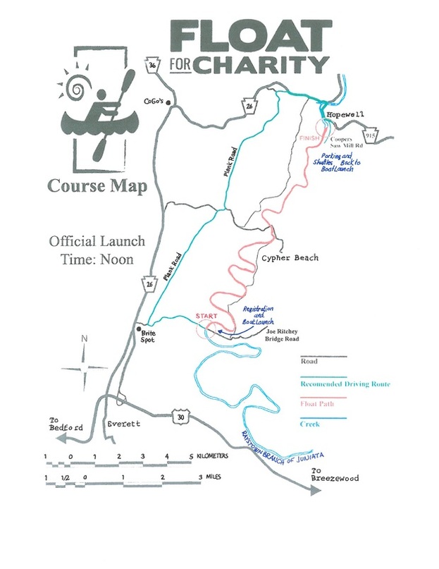
From Joe Ritchey Bridge (Launch Site) to Cooper's Recreation Area (Water Exit, Vehicle Parking, Shuttle Bus Pick Up)
From Joe Ritchey Bridge head west on Ritchey Bridge Rd/SR 1012 1.7 miles
Merge with Plank Road and follow Plank Road/SR 1009 0.1 mile
At stop sign turn right onto PA 26/Raystown Road. 10.8 miles
Just past Linda’s Little General turn right at Green Steel Bridge 0.6 mile
onto PA 915/S/Front Street.
Follow River- Turn right at dirt road onto Cooper Sawmill Rd to 1.3 miles
Float for Charity parking lot.
Directions
Directions from Altoona, PA and I=99 to Joe Ritchey Bridge, Tatesville, PA 15537
Directions from Huntingdon, PA to Joe Ritchey Bridge, Tatesville, PA 15537
Directions from Bedford, PA and I-99 to Joe Ritchey Bridge, Tatesville, PA 15537
Directions from Breezewood and Route 70 to Joe Ritchey Bridge, Tatesville, PA
1. Take Route 30 West to Everett, PA and Route 26 Raystown Road North to Tatesville, PA 15537 (aprox. 3 miles from Everett)
2. turn right at the "Brite Spot"
3. travel (aprox. 2.5 miles to Ritchey Bridge Road to Ritchey Bridge
4. Launch site will be on the left.
Directions from Joe Ritchey Bridge to Coopers Sawmill, Hopewell, PA 16650
1. Travel (aprox. 2.5 miles) to Tatesville and Route 26 North
2. turn right on Route 26 and travel (approx. 10.8 miles) to Hopewell, PA 16650
3. Turn right across the bridge into Hopewell, PA on Route 915 South (aprox. .06 of a mile) to Sawmill Road
4. turn right on Coopers Saw Mill Road and travel (1.3 miles) to Coopers Recreation Area
From Joe Ritchey Bridge head west on Ritchey Bridge Rd/SR 1012 1.7 miles
Merge with Plank Road and follow Plank Road/SR 1009 0.1 mile
At stop sign turn right onto PA 26/Raystown Road. 10.8 miles
Just past Linda’s Little General turn right at Green Steel Bridge 0.6 mile
onto PA 915/S/Front Street.
Follow River- Turn right at dirt road onto Cooper Sawmill Rd to 1.3 miles
Float for Charity parking lot.
Directions
Directions from Altoona, PA and I=99 to Joe Ritchey Bridge, Tatesville, PA 15537
- Take Route 36 South to Route 26 Raystown Road
- Take Raystown Road South to Tatesville (aprox. 5 miles)
- Turn left at the "Britet Spot"
- Travel (approx. 2.5 miles) on the Ritchey Bridge Road to Ritchey Bridge
- Launch site will be on the left
Directions from Huntingdon, PA to Joe Ritchey Bridge, Tatesville, PA 15537
- Take Route 26 Raystown road South to Tatesville (aprox. 30 miles)
- Turn left at the "Britet Spot"
- Travel (approx. 2.5 miles) on Ritchey Bridge Road to Ritchey Bridge
- launch site will be on the left
Directions from Bedford, PA and I-99 to Joe Ritchey Bridge, Tatesville, PA 15537
- Take Route 30 East to Everett, PA and Route 26 Raystown Road North of Tatesville, PA 15537 (aprox. 3 miles from Everett)
- Turn right at the "Brite Spot"
- Travel (aprox. 2.5 miles) on Ritchey Bridge Road to Ritchey Bridge
- Launch site will be on the left.
Directions from Breezewood and Route 70 to Joe Ritchey Bridge, Tatesville, PA
1. Take Route 30 West to Everett, PA and Route 26 Raystown Road North to Tatesville, PA 15537 (aprox. 3 miles from Everett)
2. turn right at the "Brite Spot"
3. travel (aprox. 2.5 miles to Ritchey Bridge Road to Ritchey Bridge
4. Launch site will be on the left.
Directions from Joe Ritchey Bridge to Coopers Sawmill, Hopewell, PA 16650
1. Travel (aprox. 2.5 miles) to Tatesville and Route 26 North
2. turn right on Route 26 and travel (approx. 10.8 miles) to Hopewell, PA 16650
3. Turn right across the bridge into Hopewell, PA on Route 915 South (aprox. .06 of a mile) to Sawmill Road
4. turn right on Coopers Saw Mill Road and travel (1.3 miles) to Coopers Recreation Area
